The Most Challenging 1.5 Mile Hike I Have Done So Far.
Bryce Canyon National Park in Utah, USA has some of the most unique landscapes I have ever seen!! It is known for it’s red/crimson colored Hoodoo’s. What the heck are Hoodoo’s you ask?? lol They are rock formations that could be literally shaped in any type of irregular formation. The protrude from the ground up. They are usually made of around 4 different rock “types”. These rock types erode away at different speeds. This is why you will see such irregular formations within the hoodoo’s. Either the top parts of the hoodooo’s, the middle or the bottom parts are going to erode faster that the others thus creating an irregular formation.

Bryce Canyon is not a huge park but it is packed with lots of gorgeous scenery! There is a main road through the park that is approx 18 miles long. It takes you from one end of the narrow park to the other. On this drive there are multiple areas where you can pull off and see some of the spectacular beauty without even hiking. SO if your more of a site see’r by car then your in luck. If your an avid hiker well let me tell yah there are miles upon miles of hiking here!

I have been hiking a lot lately but I am no where near a pro hiker. I normally hike around 6-7 mile hikes (this goes up every year as I push myself to go further!) and in elevations anywhere from 2,000-6,000 feet. But…let me tell you THIS hike in Bryce Canyon game me a challenge lol!! For only being 1.5 miles round trip it was the toughest mile and a half I have done thus far!
Navajo Loop Trail
Hiking Details-
- Length – roughly 1.5 miles
- Approximately 600 feet elevation change
- Difficulty – Moderate
- Time it may take – 1-3 hours
- Hike starts at roughly 8,000 feet and drops to around 7,400-7,500 feet
We parked at Sunrise Point which is less than a mile into the park on the left. From here you can either walk along a nice flat path on the rim and gaze in amazement at the deep canyon below you. Or you also have the option to start the hike from this point and head down to an area called “Queens Garden Trail”. This hike is roughly .8 miles to Navajo Trail.
We took the path along the rim as we wanted a good vantage point to take some photos of the whole canyon below. As you walk along the rim there are benches and lots of nice flat areas to just to sit and relax while you really take in all the gorgeous landscape. This upper path between sunrise and sunset points is one of the very few dog friendly trails. Navajo trail is not.

You will really get a good idea just how many hoodoos and pinnacles there are and the INCREDIBLE formations that they have made. I was seriously in awe! I haven’t seen anything like this before and I thought to myself how blessed I am to be in that spot and in that moment! I really took some time to just “look”!

Continuing on the path you will soon come to Sunset point. This is where the Navajo Loop trail starts and ends. It takes you through some of the most gorgeous settings in Bryce Canyon.
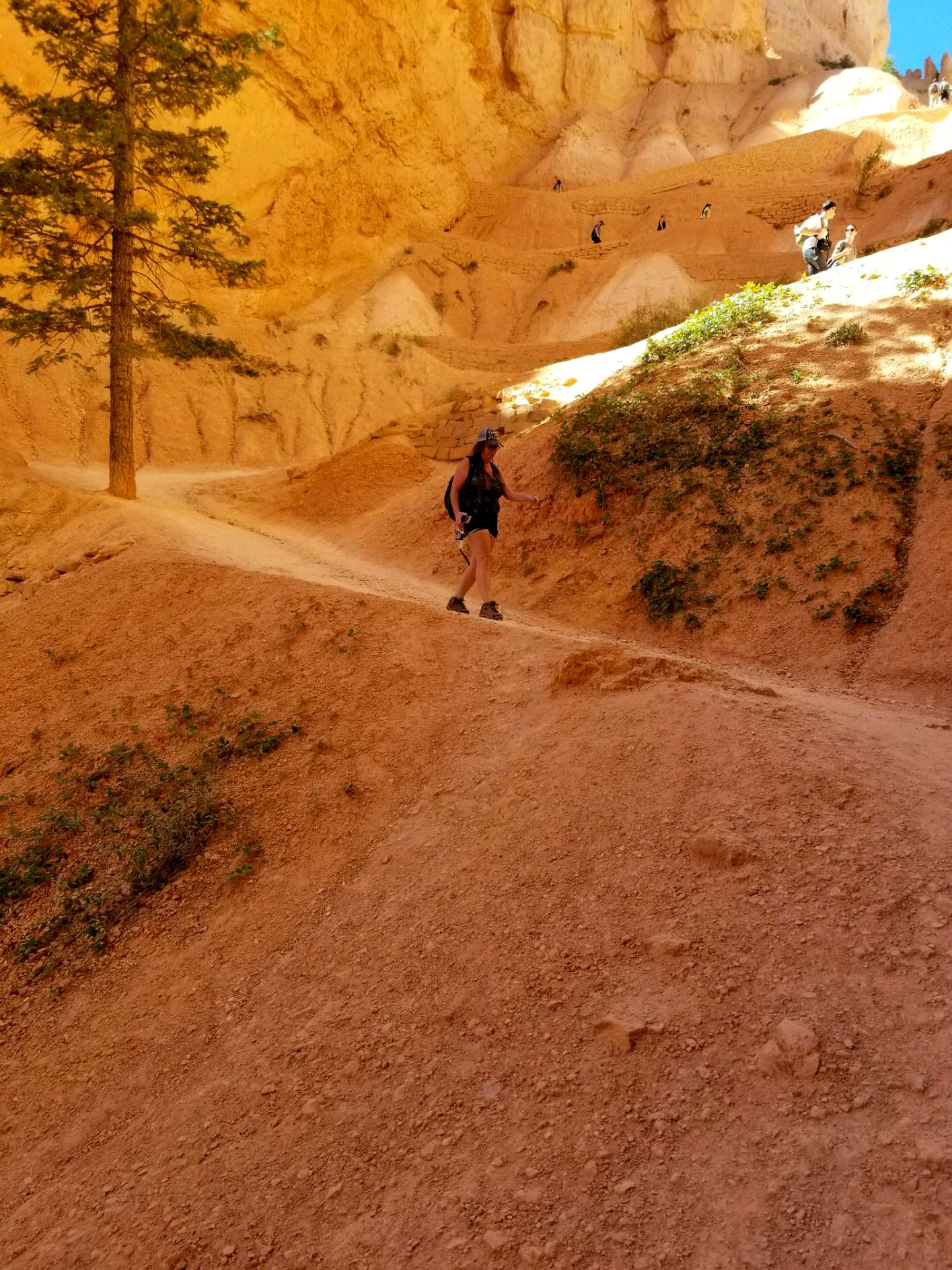
We started our jaunt down on the eastern side of the loop. There is roughly 550 feet in elevation change in this hike. It wouldn’t normally be to bad to drop that much in elevation but your starting this hike at roughly 8,000 feet! Um yeah I said 8,000 feet! LOL! So as you can imagine the descent down is pretty rapid. So be prepared and bring lots of water and good shoes! The trail is fairly flat but it has some loose dirt in areas so make sure your shoes have good traction. Don’t rush this hike, take your time as there is sooo much to see.

The other aspect to be aware of is heat. There are portions that are in the sun and shade so you want to make sure that you have a layer for chilly shaded areas depending on what month you go. Also hats and sunscreen for those sunny sections. There are some well known sites to see on this trail as your heading down towards the canyon floor. Not far from the start of the trail you will come across this famous hoodoo (Possibly named Windows) that has eroded away and made “windows”. I think it looks like a face lol. Do you see what I am seeing? The eyes and the lips and the forehead 🙂 It’s very cool how erosion shapes each of these structures so differently. You could spend hours just looking at the detail in amazement.

Also along this section of trail you will also see Thors Hammer. If you look to the left of the trail you will see the hoodoo with a big boulder looking formation on a skinnier pillar. It is amazing how the bigger part of that formation just rests on a smaller pillar beneath it! The hoodoo’s below it almost look like a palace or city. What do you think? Do you see any cool formations?

After passing some of these well known HooDoo’s the trail starts to decend at a rapid rate again. Several switch backs take you down to the bottom floor. I’m not going to lie the back of my shins were feeling the work out lol. You would think walking down hill is easy but when your descending rapidly you need to “hold yourself back” kinda like a car dropping into 2nd gear and having a little bit of a braking system going on lol!
But look how gorgeous that is!! Aren’t these switchbacks beautiful? And those pine trees ahhh…I love pine trees!

When you get to the last few switch backs you can see the valley floor just ahead! The pine trees start to become more abundant and the scenery starts to take on a little different appearance. The very last part of this descend flattens out right in the middle of those cliffs. You will progress right in the middle of them for a mini slot canyon experience 🙂

When you come out on to the valley floor it feels more like a mountain landscape with all the pines lol. There is another trail head here (Queens Garden Trail) that takes you farther into the valley floor and back toward Sunrise point. We decided to continue on the loop. You can see up in the sky there was a helicopter. That is because while we were there visiting a park there was an active fire going on at the very back of the park. We were all safe but I felt sad that there was a fire most likely destroying a beautiful area within the park.

After spending some time on the valley floor we continued on the loop which then starts to take us back up the 550 feet lol. This section of trail is called Wall Street. It has some gorgeous parts to it for sure and a must see! You will hike right up against the sides of the canyon walls and there are even parts that overhang. Always be on alert as these areas can have rock slides or parts of the canyon wall break off due to erosion.

There are areas within this section to climb up and get those awesome photos 🙂 My husband was a good sport and climbed up a section and posed for a photo lol. The Wall Street section of the hike is usually closed off in winter due to water run off and winter conditions. If you look at the formation of the canyon walls behind my husband you can see how the water rushes through it and forms those patterns. Just beautiful!! Like a slot canyon!

Wall street is considered more of a narrower area of the hike and here you will get a small version of what a slot canyon is like. The different formations in this area resemble that of a lava flow. Isn’t this pretty?? Now isn’t this hike worth the work? 🙂

After getting all those cool photo ops it’s time to hike upward towards the top yay! Not! haha No really it was a little challenging but totally do’able! You will start back up a few switchbacks at a time in this section. Don’t forget to still take moments to stop and look at the scenery, you definitely don’t want to miss out on that scenery! This portion of the hike is just as beautiful as the rest but yet has its own set of unique structures.

After those few set of switchbacks you will round the corner and see the last jaunt of the trail. It’s all upwards from here lol! The switchback gain elevation quite rapidly in this section. Time to put it in 4 wheel drive and push forward lol! I took several breaks and it didn’t bother me to do so lol! While taking breaks I took more pictures. I was still so amazed at all of those gorgeous hoodoo’s. Do you see that pine tree way off into the distance? The very top of this hike is to the right of that pine tree 🙂 Not that far right? lol

I will most likely do this trail again when I visit Bryce Canyon this summer. Yes it was challenging BUT the beauty within it is SOOOO amazing! I really would like to spend more time there taking photos and maybe take one of the side trails and explore further!
Have you done this trail? If you have what did you love about it? If you haven’t would you try this one?
Chat Soon!,
Trudy
About The Author
Trudy
Related Posts

What to do for beginners in Zion National Park
If you haven’t been to Zion National Park before then put it on…
February 22, 2019
#6 of 80 Adventures To Do In California – Hiking Horsetail Falls
Heading East in Central California along highway 50, the scenery changes from a beautiful valley…
February 22, 2019